

Ralston Peak is located in the Sierra Nevada mountain range to the west of Lake Tahoe in Desolation Wilderness. The drive from Davis to the Ralston Trailhead near Twin Bridges is about an hour and thirty-five minutes. The parking lot isn't huge so it's best to get there early. We were there around 8:30am on a Saturday morning and there were still spots. The lot is right off of Highway 50. 

There are actually a few parking spots where the trail actually starts. It is located about a .2 mile walk from the parking lot near the highway. You won't miss it because of the big trail sign (seen below) and it is where you would probably normally get your Desolation Wilderness day pass (not required this year due to COVID). Then we were off. The trail starts out in the trees. The climb is gradual at first.


 There are some pretty steep sections on the climb. My 12 year old had no problem hiking them, however it was hard for me to keep up.


I liked how there were some flat portions so your legs can get a little break from the climb. We did see a bear cross the trail! It was pretty exciting. We were far from the bear, so weren't too worried. If anything the boys wanted to see more of it, but it wandered off in the direction opposite of where we were going.

Here's the part of the trail where we entered Desolation Wilderness.


Below is one of those steep sections and it is hard to see him since he is so far ahead of me, but he is there.

The last bit to the top is steep and on talus rock. 12 year old didn't quite follow the actual trail up on the last part so we were on the talus longer than we had to be. We still got to where we needed to go. :)


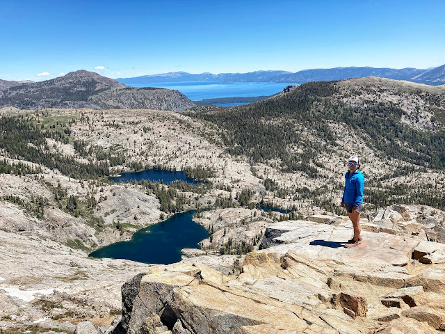
The views at the top are AMAZING!!! You get views of Upper and Lower Echo lakes, Lake Tahoe, Fallen Leaf Lake, Tamarack Lake, Pyramid Peak, Lake Aloha...and others I don't know the name of. This is easily now one of my favorites because of the incredible views you get.
 Here's a shot of Hubby on the summit and by the summit registers (there were 3 cannisters).

 Had to get a family shot. :)

 After having lunch and spending about 20 minutes just soaking the views, we headed back down.
 A break in the shade.

 Per my Strava, total moving time came to 3:29:12 and elapsed time 5:59:38. Overall, I thought this hike was awesome. It's one I would definitely do again and definitely recommend because the views are just so good. :)


My 10 year old with a summit cannister.


Me and Hubby with Lake Aloha in the background.

Here's some video I took while on the summit.


The hike came out to 6.84 miles with 2,815 elevation gain. This data comes from my Garmin 945 watch.

Happy hiking!
No comments:
Post a Comment